An application designed for landscape photographers. #Landscape photographers #Landscape photography #Adobe AIR #Landscape #Photography #Sunrise
Landscape photographers typically wish to plan their shoots around the times of sunset/sunrise or twilight, or alternatively when the moon is in a particular place in a particular phase.
While times of sunrise etc. are readily available on various sites on the internet (direction of sunrise etc. less so, but still readily found), there are fewer programs available which combine such information with a topographical map allowing the photographer to match the astronomical to the location.
A typical use might be to determine when the sun will set along the axis of a mountain valley, or when a full moon rise will rise across a lake.
The application uses Google Maps providing users the ability to select a location and determine the time and azimuth of sunrise or sunset for a given date or dates.
Not a huge amount – there are other programs out there that calculate the same data and more.
What I haven’t seen before is the combination of the key data together with a topographical map, courtesy of Google, in one program for either Windows or Mac.
If you’re already on location, this isn’t probably going to help. If you’re planning a trip, then perhaps this is the program for you.
Nothing. It’s free. Help yourself.
Hopefully, the program will prove fairly straightforward to navigate. If not, here are some quick tips on usage. The basic idea is as follows:
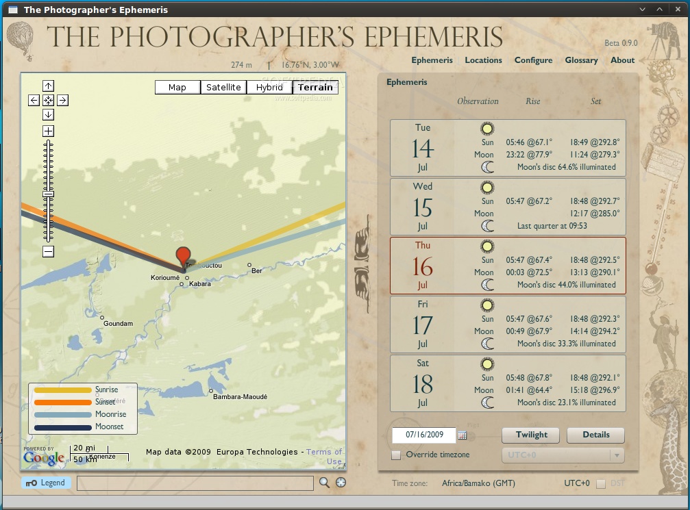
1) Pan around on the map to find a location you’re interested in, or drag and drop the red marker. Click the Center button (located at bottom right of map, or press ‘C’) to place marker at the centre of the map
2) The “Ephemeris” table on the right shows you the sunrise/sunset/moonris/moonset times (plus azimuths and phase of moon). Click the Twilight button to see twilight times instead
3) Click the up and down hands to advance dates (or press ‘P’ – previous, ‘N’ – next or ‘-’ and ‘+’ on the main keyboard), or select a different date from the date selector
4) The timezone of the location should be detected automatically and displayed at the lower right of the window (if timezone is not shown, you can click override and select manually)
5) The latitude, longitude and altitude of the current marker position are displayed at the top of the map.
6) If you want to determine the nearest placename of the current map location, click the Search button (the magnifying glass) below the map.
7) If you want to search for a specific named place, click into the location text box (left of the search button) and type the name of the place you want to find. If Google can find it, the map and marker will move to that location.
8) Click Locations (top right) and you can save your current location, or go to or delete one that you saved earlier.
9) Certain labelled terms throughout the program have glossary entries – any label that turns reddish when the mouse is over it will, when clicked, display the corresponding glossary entry. (Note – the glossary is not entirely complete yet.)
10) If the shot you’re looking for isn’t right at the moment of sunrise or moonset, click the Details button (or press ‘D’ on the keyboard) to see detailed information for how the sun and moon are positioned throughout the day and night at your selected location. The upper panel allows you to set an arbitrary time of day and see azimuth and elevation angle information numerically. You can also click between the various celestial events for the day using the skip buttons. The lower panel shows the elevation angle for sun and moon throughout the day. (Those three lines below the 0° line represent the elevation angle of the sun at the various twilight boundaries: -6°, -12° and -18°.)
The idea is that a photographer scouting locations would use Google’s topographic map to see the contours of the location and then, assuming they want to shoot the “golden hour” would want to see where and when the sun/moon will rise/set. The lines on the map show you the direction of sun/moon rise/set.
There are a handful of keyboard shortcuts you can use:
* E to display the Ephemeris screen * L to go to Locations * P or - for the previous day * N or = for the next day * T to toggle display of twilight information (new in Beta 0.7.4) * D to toggle display of details information for the selected date (new in Beta 0.8.0) * C and Shift-C to (i) place the marker at the centre of the current map display or (ii) to pan the map to place the marker at the centre of the display * Shift – hold down this key to extend the azimuth lines displayed on the map through the marker location. This is helpful for aligning particular landmarks, your shooting location and the direction of the sun/moon. This function only works when you are sufficiently zoomed in (otherwise, the extended azimuth line would be inaccurate and misleading)
Units of Distance: determines units used for location altitude (metres or feet) and distance to nearest known place (km or miles)
Default location names: select preferred format for displayed location name (as shown during reverse geocoding, i.e. what’s the nearest place to here?) and default name provided when saving a location
Service timeout (seconds): determines the default timeout when querying the GeoNames webservices for timezone, altitude and nearest placename. Consider increasing this value if you are seeing “Request timeout – retrying” or “Request timed out” messages. (The specified value is used as is for timezone and altitude queties, but in fact is doubled internally for reverse geocoding as this service can normally take longer to respond, particularly if the nearest known placename is some distance from your current specified location.)
Timezone management: not user editable. Checked if the timezone management database is correctly installed.
Azimuth lines: user selectable colours for the lines shown on the map indicating direction of sunrise/sunset/moonrise/moonset. The same colours are used in the Details display.
Adobe AIR runtime allows Adobe AIR applications to be deployed on computers and devices running the Linux operating system. Adobe Flex Builder for Linux can be used to build rich internet applications that deploy to the desktop and run across operating systems using proven web technologies.
System requirements
The Photographer's Ephemeris 1.0.4
add to watchlist add to download basket send us an update REPORT- runs on:
- Linux
- filename:
- tpe_1_0_4.air
- main category:
- Adobe AIR Apps
- developer:
- visit homepage
Windows Sandbox Launcher 1.0.0

IrfanView 4.67

ShareX 16.0.1

4k Video Downloader 1.5.3.0080 Plus / 4.30.0.5655

calibre 7.9.0

Zoom Client 6.0.3.37634

Bitdefender Antivirus Free 27.0.35.146

Microsoft Teams 24060.3102.2733.5911 Home / 1.7.00.7956 Work

7-Zip 23.01 / 24.04 Beta

Context Menu Manager 3.3.3.1

- Microsoft Teams
- 7-Zip
- Context Menu Manager
- Windows Sandbox Launcher
- IrfanView
- ShareX
- 4k Video Downloader
- calibre
- Zoom Client
- Bitdefender Antivirus Free